- About
- Admin. Boundaries
- Base Maps
- Cadastral
- Digital Elevation Models
- Digital Imagery
- Environment
- Forest Inventory
- Geographical Names
- Geology Mapping
- Hydrography
- Land Use/Cover MapsMunicipal Maps
- Quarter Section Grids
- Soil Classification
- Spatial Referencing
- Topographic Maps
- Town & Village Plans
- Transportation
- Comments
Related Sites
Canada Map Sales

To view PDF files, you must have a copy of the Adobe Acrobat Reader which is available as a free download:
![]()
Manitoba Land Initiative
Core Maps - Data Warehouse
Cadastral Mapping
|
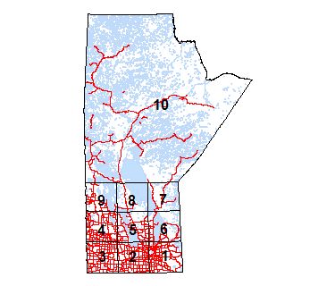
Click on general area of interest for further map selection |
||
 |
||
|
Tabular selection |
||
| Update Info | Metadata | Version | Date | .GDB | |
| Manitoba Cadastral Polygons | .XLSX | .XML .PDF | 2.001 | 2018-03-27 | .GDB |
The Manitoba Cadastral Polygons dataset contains three types of GeoManitoba Cadastral Mapping products together in one seamless product. The Northern Theoretical Tiles, the Southern Reference Grid and the most accurate southern Cadastral Mapping datasets are combined into this dataset.